Look what you could have won
How it startedIt started with a phone call from David in Laragne: "Would you like be the scorer for the Ozone Chabre Open.... " back in September 2005. "OK" I replied not knowing if I was doing anything the following June.
I wasn't sure whether to wind dummy for the competition or enter, so I entered knowing that it would be easy to just fly to the campsite and start downloading when required; taking-off as soon as the window opened.
I imagine that worrying about the scoring must have distracted me from flying as averagely as normal and somehow when the week finished I was top of the non-handicapped results. The prize was a Sail Plane flight in tandem with Klaus from Quo Vadis based in Serres; holder of the sail plane distance record of over 3000km. So this is what we did:
Briefing at 10:00 early August
This seemed quite civilised to me. Klaus' briefing room was in a cabin at the airfield and most of the sail plane pilots staying at the airfield gathered around to hear the oracle's words before the days adventures. The forcast was a little too in depth for my comprehension; talking about the winds in Italy and over the Rhone, the depression over Ireland... he did it in English too! The summary was light winds, thermic with very little chance of wave; we'd probably stay local.
Take off 13:00
As you can see the glider looked well smart, and was very clean and white! The third photo shows how the nose cone came forward and as if by magic the propellor appears! Klaus' glider is in fact too heavy to be aero-towed, but the built-in motor is VERY powerful; "..really it is more of an aeroplane than a glider.." says Klaus. You can also see me sporting the latest in parachute design: We went through the bailing out procedure and the throwing up procedure, neither of which were required. The fourth photo shows the array of instruments, the left hand side were the gliding ones and the right hand side the motor ones, and a radio one in the middle.
 01 Klaus' Clean Glider |
 02 Comfy Chairs, oxygen bottles, just in case |
 03 Nice parachute |
 04 Technofear |
The normal way to launch is to do all of the checks, attach a tow line and go! Following the plane in front looked particularly difficult and the second most scary part of the flight. Photos 5 to 7 show some non-motor gliders taking off. We used the motor; chocks away tally ho and within 10 minutes were soaring on the hills to the north of Serres. Photo 8 shows the view looking East back to the air field.
 05 Ready to tow |
 06 Taking off |
 07 Follow that 'plane |
 08 Airborne |

First Thermals
After about half an hour of soaring at 100km/h we (Klaus really, I was just inanely grinning ballast) found a climb and climbed to 1800m. That was the cue to drop back onto the Beaumont ridge, well known to us all as a good thermal source. It worked and the climb there took us to 2300m.
I found the thermalling very enjoyable, it felt like the glider was banked up at about 45 degrees and around we went.. and the airspeed was still 100km/h!
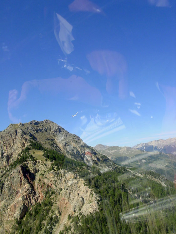
Photo 9 shows the Chabre take off from the North side (the view from Beaumont), with Laragne town on the left.
From there we went on a glide at 160km/h over Sisteron to St Geniez; about 45km with little lift and no clouds.. Fantastic! The Climb at St Geniez (another paragliding launch site) took us to 2150m and the first signs of cloud.
Klaus' gliding operation involves leading a formation of gliders around the sky. Today we had three people following very closely behind. When Klaus pushed a lever forward and alarm bells started ringing, he took us into a steep and fast dive. Pulling out and restoring the lever position he carried on smiling! He'd used the air brakes to drop some height so that his group could stay together.. nice to be warned!
Photo 10 is St Geniez from the SE. Photo 11 is looking SE with Digne obscured to the right and the famous Cheval Blanc in the middle distance.
One thing that struck me was travelling between clouds: We would leave a cloud, head for the next and get there. The cloud would still be there and we'd arrive high enough to use it.. most strange!
After finding a couple of clouds we were at 2900m half way to Allos, where photo 12 shows the town of Seyne in the foreground and the Dormillouse ridge on the right. The ski field half way up the ridge is quite clear (the large patch of green) and the lake (Serre-Poncon) is just visible in the center-left.
 09 Chabre Ridge |
 10 St Geniez |
 11 Looking SW |
 12 Dormillouse |
Heading South
We headed further towards the Dormillouse at around 1900m (photo 13). It was incredible gliding towards the ridge and arriving above it! Photo 14 is taken from the ridge itself looking West down on a turnpoint used in the British open in 2003 where about 25 of us landed, and a few others had to walk out down the river bed and into the distance.
"Where are we going?" I asked "Following the clouds.. " Klaus replied "..to Nice I think."
We flew over and beyond the ridge and turned right heading between ski fields; Pra-Loup to the left and Allos to the right. Photo 15 is taken looking towards Italy.
To Nice we headed, between 3000m and 3300m all the way at 100 miles an hour. The sky cleared 11km North of Greolieres and it seemed like a good time to turn back as the sea influence could have made going further quite tricky. We'd taken off just over 2 hours earlier.
Gliding North and fast we headed to Italy. Photo 16 is Klaus contemplating Pizza (or maybe German Sausage) looking West at Becs Du Corborant, right on the Italian border with Isola 2000 ski resort just to the South.
 13 Téte De L'Estrop |
 14 Saume Longe |
 15 Looking W |
 16 Kaus and Italy |
Heading North
We followed the ridge line over some lakes and climbed at the head of the valley. Klaus pushed the stick forward and I chuckled uncontrollably as we hit 260km/h. Cime De La Bonette is a col with a lookout and we both waved at the on lookers whilst we did a lap of the pinnacle.. four gliders passing at high speed; what a bunch of poseurs!
A little further on we hit the first rough climb at Téte De Siguret. In the rough climbs you have to keep more airspeed and be very aggressive with the controls.
We passed East of Pra Loup and lake Serre-Poncon (photo 17), photo 18 is looking North into the Ecrins with the Glacier Blanc in the center and Guillestre (I think) in the foreground.
All of the clouds were now to the south of us and it felt like we were cruising easily; big blue thermals and long cruisy glides. But then we spent the next 30 minutes without any significant lift. From Téte De Siguret 40km to beyond L'Argentiere and 20km back to ridge soar back near Guillestre. "Very strange that these ridges aren't working but we can always go up at Guillestre.." said the driver. Photos 19 and 20 were taken looking North and up at our escorts in the peaks just to the North of L'Argentiere.
 17 Pra-Loup |
 18 Glacier Blanc in the Ecrins |
 19 Escort 1 |
 20 Escort 2 |
We'd hit a low of 1600m before soaring up to just above ridge height at 2400m (photo 21); the sink rate of this glider is 0.6m/s, about half that of mine.
Getting higher was a struggle and pretty rough due to an inversion and then it took a further 15 minutes to climb to 2700m and glide into the gullies behind. This was truely spectacular; seemingly no way out with high cliffs and barren rock, it was somewhere I would never dare to go with a paraglider. We continued around this moonscape not hitting any lift until we'd gone full semi circle.
Finally we hit a climb to 3100m and the inversion was left well below. Onward along the high ridges to Briancon (photo 22 looking directly North) over Montgenevre and North towards Bardonecchia in Italy.
It was 17:30 100km from home, 9km South of Bardonecchia and time to head back.
 21 Ridge Soaring |
 22 Briancon |
 23 Glacier Blanc |
 24 Getting Higher |
The Ecrins
We headed South of West for 15km, this time North of Briancon and climbing on the peaks to 3500m, then a sharp right towards the Glacier Blanc (photo 23).
Along the high cliffs photo 24 shows one of the icy tops at 3400m to the SE of the Glacier (looking NE). Photo 25 shows the view looking SW and photo 26 looking E. At the head of the valley is the Glacier itself (photos 27 and 28). The peak to the left is at 4100m whilst we were at 3500m. With the sun blazing through the canopy the air was cool and very comfortable.
 25 Ice Flows |
 26 Ice Flows |
 27 Glacier Blanc |
 28 Glacier Blanc |
We headed back the way we came and at the entrance to the valley found another climb to our high point of 3740m. Photo 29 is the view to the North; Mont Blanc is on the horizon to the left - I would have loved to have visited it!
"We'll take a short cut.." says Klaus, and we headed straight into the mountains over ridges that were seemingly too high. We went SW (photo 30) through the valleys towards Orcieres where I picked up David and Rachael on the radio.. they were paragliding at 2200m and couldn't break through the inversion. We cut South where Photo 31 shows the view back to Italy and 32 shows Savines at the beginning of a huge valley crossing over lake Serre- Poncon: We were at 2750m and Klaus seemed confident we'll make it.
 29 Mt Blanc |
 30 Looking SW |
 31 Towards Italy |
 32 Savines-Le-Lac |
Final Glide
We make it! We passed the mountain overlooking St Vincent and made the next crossing back onto Dormillouse; a 20km stretch where we lost around 300m! Photo 33 shows St Vincent in the center of the frame with the Dormillouse to the left. There were a dozen paragliders around the launch seemingly not getting very high. As if to show off Klaus went in a straight line all the way to the end of the ridge, another 17km slowly climbing. A quick 3 minute thermal to 3100m at the end and back we went before turning West and heading home with 55km to go. We passed to the South of lake Serre-Poncon and clearly saw where the two arms of the lake join (Photo 34).
Its not very obvious, but the next 20km are a bit wobbly on the track log; thats because I was driving. Trying to keep the glider straight I found quite challenging as it gradually drifted left then right. One of the guys following said he was starting to feel air sick so I gave up.
There were no more thermals. We passed South West of Laragne (photo 35), North of the volcano (St Genis), North of the Shark's fin and arrived with 600m above the airfield.
Klaus had one more trick up his sleeve; a fast dive then pull up 'till we nearly stop, then turning left to pick up speed again type manoeuvre. That was fab!
 33 St Vincent |
 34 Serre Poncon |
 35 Laragne Chabre |
Finally we did a circuit around the runway with the airbrakes on and the wheels down. We came in to land for the most scary part of the flight.. a slight down wind landing at 150km/h, a quick bounce and on with the brakes. We slid gracefully next to the hanger not having to push the glider anywhere.
It was 19:40, six hours and a 340km FAI trangle, nearer 450km adding up each leg. Quite a fantastic day in another sort of glider.. a bit faster and more performant than the one I'm used to.
Thanks to Klaus for donating the prize, to Ozone and Allez-up for organising the competition and everyone who entered the competition for letting me win it!
Report by Mark Graham